1813 Campaign
The rules can be used for any campaign. But I think it will be easier to understand the thought process behind them if you have an idea of how my 1813 campaign works.
The campaign has been designed to provide interesting wargames using all of our model soldiers and model scenery.
There are two campaign strategic maps, one of Germany and one of Spain Europe . Each grid square on the map is an area of 20 miles. This is also one days march for each corps.
There are three French armies in Germany
There are two French armies in Spain
Campaign Maps
There are three maps for each campaign. I will only show the Spanish maps to illustrate what they look like.
 Strategic Map of Spain
First is the overall strategic map. The map has been copied from the AA Atlas of Europe . However most of it has been changed to make it more of a campaign map, and less of a road map. The geographical features such as rivers and towns are correct. The mountain ranges are little more than a guess. The roads in red are the main supply routes. They run between major cities. The yellow are secondary roads. They connect towns and villages within each region. This is the master map from which all other maps are copied.
 Strategic Map for Valladolid Campaign
The second is a more detailed map for the strategic movement. This one is used for the Burgos Madrid and Bayonne
 Extract from Strategic Map to make the Tactical Map
The third map covers an area 80 by 60 miles. This is the area which will be transferred to the tactical map. I have not yet made the tactical map in ProFantasy. I will use a hand drawn one from a previous campaign to illustrate.
 Tactical Mapfor Tarragona Campaign
This is a hand drawn map which I used for the Tarragona
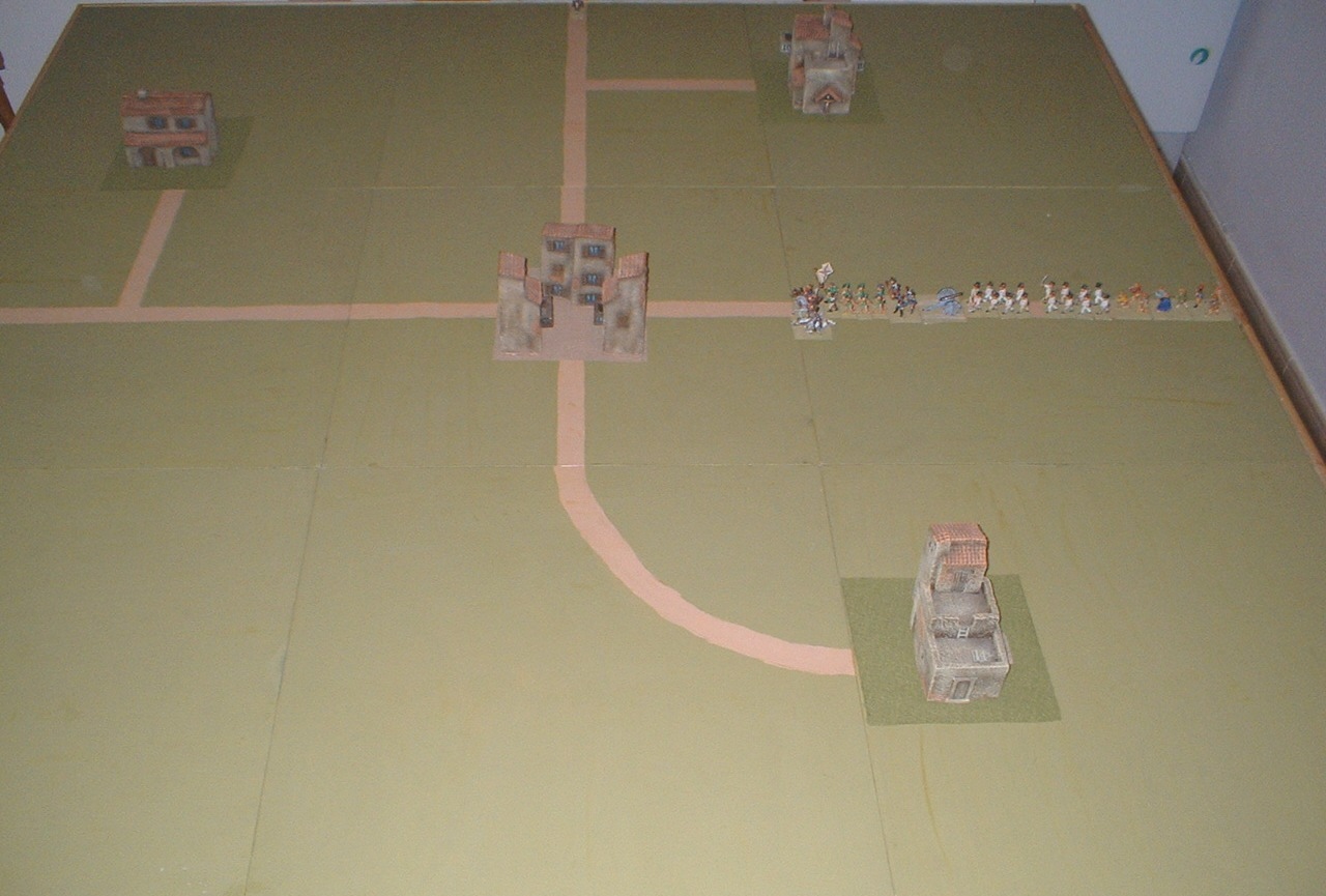 The wargames table at the start of the game
The campaign is the background to the wargame. It provides a reason for each game, and also an endless supply of games without too much effort.
2 comments:
Hello Paul,
Stumbled upon your Napoleonic gaming site and find myself keenly interested! Some questions, please:
1. How did you get the digital version of your maps - the one of Spain and the more "zoomed in" version you show on the site under Campaign Rules?
2. Do you use imagination to fill in your paper maps or do you use some reference?
3. You are so very fortunate to have mate that plays games with you! Do you ever find yourself playing solo? What mechanisms do you use with your rules in solo mode - if you play solo, that is?
Thanks for sharing all this info and your ideas.
Mike
Hi Mike
Sorry its taken so long to reply, I was not send an email that you has posted a comment.
I make my maps using Profantasy CC3. Its a commercial map making programme. Very easy to use and not very expensive.
All of my maps are made using an AA Road Atlas of Europe. The location of rivers and towns are reasonably accurate. I use a road system which connects capital cities and major towns, reasonably historical. The rest if imagination.
My wife Jan and I have wargamed together for many years. I have run clubs over the years, but now we just wargame together. Its difficult to do anything else when you run a fast moving campaign.
Fortunately I have never had to play solo.
The rules, both campaign and wargames, are designed to play large battles using the model soldier in my collection. The troop ratio is not important, so I would expect that they can be used with any combination of troops on any size stands.
If you would like to know more about the current maps and campaign you should have a look at
http://1814campaigndiary.blogspot.com.es/
regards
Paul
Post a Comment